
International Journal of Business Research and Management
OPEN ACCESS | Volume 5 - Issue 2 - 2026
ISSN No: 3065-6753 | Journal DOI: 10.61148/3065-6753/IJBRM


Asst. Prof. Mehmet Çağrı Kızıltaş1*, Furkan Kalkan2
1Asst. Prof., Civil Engineering Department, Engineering and Architecture Faculty, Istanbul Beykent University, Istanbul, Türkiye.
2Computer Science and Engineering – Intelligent Systems Department, Institute of Computer Science and Cybersecurity, Peter the Great St. Petersburg Polytechnic University, St. Petersburg, Russia.
*Corresponding Author: Asst. Prof. Mehmet Çağrı Kızıltaş, Civil Engineering Department, Engineering and Architecture Faculty, Istanbul Beykent University, Istanbul, Türkiye.
Received: September 25, 2026 | Accepted: September 05, 2026 | Published: October 09, 2026
Citation: Mehmet Ç Kızıltaş, Kalkan F., (2026). “An Analysis of Metropolization and High-Capacity Transportation of Brazil Via Clustering Methods”. International Journal of Business Research and Management 5(2); DOI: 10.61148/3065-6753/IJBRM/104.
Copyright: © 2026. Mehmet Çağrı Kızıltaş. This is an open access article distributed under the Creative Commons Attribution License, which permits unrestricted use, distribution, and reproduction in any medium, provided the original work is properly cited.
High-speed systems and networks are the most important elements of transportation infrastructure and city. It is an infrastructural concept that is related to high standard and high technology services. This systematic has a critic role for tourism attractiveness. In this paper, a cluster-based analysis was conducted for Brazil, which is on a strong point about big metropolitans by using population, gross domestic product, livability through cluster statistical methods. Metropolization trends were presented by taking into account the agglomerations between cities. Lastly results and suggestions were given in this context.
Clustering analysis, urban, high speed, tourism, economy
1. Introduction
Brazil is the largest country in Latin America in terms of population and area. The country is the second largest in terms of population and the third largest in terms of area on the entire American continent. The country covers approximately half of the South American continent with its 8.514 million km² of land. Brazil encompasses almost the entire eastern part of the South American continent. In addition, its territory especially expands to the north. The country shares borders with all countries in the Americas except Chile and Ecuador. Brazil is the 7th largest country in the world by population and the 5th largest by land area. Brazil's population is projected to be 218.56 million by 2025 (Trading Economics, 2025). São Paulo and Rio de Janeiro are the major cities, and the country has more than 13 cities with populations of over 1 million. Although the country has vast metropolitan areas, it also contains the great pristine Amazon forests. In addition to its rich and powerful nature, it also has great tourist potential. In Brazil, where Catholic religious culture is predominant, Portuguese is the official language.
In Brazil's ethnic distribution, Europeans (42-47%) and mestizos (43-45%) form the largest groups. There is a significant population of African descent (7-10%). In the country, the population of the group believed to have Arab and Ottoman origins, referred to as El Turco, is estimated to be between 6-20 million. The mestizos, who constitute one of the two largest ethnic groups in the country, are referred to as Pardo. Pardos are predominantly composed of a significant mix of Europeans, Native Americans (Indigenous people), and Africans, with Europeans being the largest group.
One of the two largest ethnic groups in the country, the European descendants, is composed of half Portuguese (42-47%), 17-20% Italian, 5-10% Spanish, 5-7% German, and 13-23% European mestizos. One of the two largest ethnic groups in the country, the Pardolar, are in the majority throughout the northern expanse of the country. This area includes the sparsely populated, forested, and pristine regions in the northeast, as well as one of the most densely populated and developed clusters in the country's northeast. Brazil's European descendants, on the other hand, are either the majority or a significant presence in almost all of the country's densely populated and developed areas. However, they constitute the majority especially in the developed regions of the country, such as the Middle East, Southeast, South, and Midwest. Portuguese, in addition to being the official language in Brazil, is quite widespread and inclusive. In addition, Spanish and English also have a certain prevalence. In summary, while Brazil is a country of cultural richness, it has largely achieved national unity through the Portuguese language and the European and Pardos ethnic cultures. All these features of Brazil hold an important position in the political, commercial, and economic integration of Latin America.
With its significant cultural affinities and connections, Brazil distinctly stands out from other countries on the South American map in terms of its official language. The official language of almost all the other countries in South America is Spanish. However, Spanish and Portuguese are mutually intelligible to a considerable extent.
The country's population density increases in the eastern regions, especially in the northeastern and southeastern regions. The northwestern region of the country is covered with large forests. A large part of Brazil is far from the risk of earthquakes. Brazil is the most important center of political integration in the South American continent and the Latin American world, and this centrality is so evident that after Brazil, Mexico and Argentina can be mentioned to some extent in this regard.
Although countries like Venezuela, Colombia, and Peru have significant strategic positions, Brazil is exceptional in terms of its strategic location, population, land area, and the geography it covers. Therefore, Brazil is at the center of the political and social integration of the Latin American world. At the center of this is having effective transportation and infrastructure systems. In addition, regular urbanization is quite important. Therefore, accurately identifying the metropolitanization trends of important countries like Brazil is a necessity. However, Brazil's priority is to be woven with a high-speed train network that has high speed, high capacity, and high comfort. In this context, this study first lists Brazil's leading cities according to parameters such as population, economic development, and levels of progressivism. Subsequently, the listed cities were clustered using statistical methods in the R Studio program. For the aforementioned cluster analysis, the K-means, Pam, and Clara methods were used in this program.
Then, the method that provides the most suitable number of clusters and the best cluster distribution was determined. Accordingly, the clustered list of Brazilian cities has been determined, and then the clusters containing the priority cities in the said clustered list have been identified. Accordingly, a comparative evaluation of these priority cities was conducted, taking distance into account, and based on this, a high-speed train network proposal and clustering trend calculations were presented.
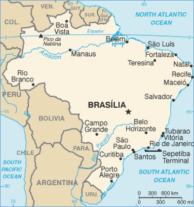
Fig. 1. Big Urbans of Brazil (Worldometer, 2025)
Brazil has a very large land area. The country has a variable climate system. Brazil has various ver big urbans on all over the world. The infrastructure development process is ongoing. Transport and traffic-related problems has local similarities with developed countries. Below on Figure 1, there are the regions of Brazil (Worldometer, 2025).
In Figure 2 Brazil state map is presented (Worldometer Politic, 2025). Figure 3 shows Brazil Geographical Map (Worldometer Info, 2025). Table 1 shows Brazil cities’ populations and liveabilities (OECD, 2020).
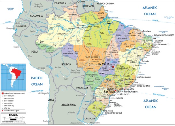
Fig. 2. Brazil State Map (Worldometer Politic, 2025)
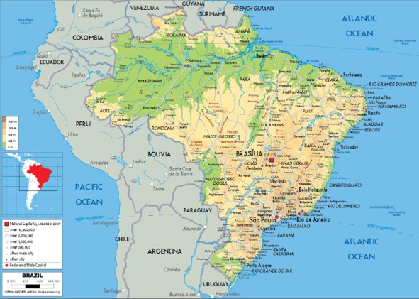
Fig. 3. Brazil Geographical Map (Worldometer Info, 2025)
Table 1: Brazil Cities Populations And Related Parameters (OECD, 2020)
|
City |
Livability |
Population |
|
Sao Paulo |
66 |
12300000 |
|
Rio de Janeiro |
64 |
6750000 |
|
Belo Horizonte |
60 |
2510000 |
|
Brasilia |
59 |
3020000 |
|
Manaus |
59 |
2220000 |
|
Porto Alegre |
59 |
1480000 |
|
Campinas |
58 |
1210000 |
|
Recife |
58 |
1650000 |
|
Curitiba |
58 |
1880000 |
|
Santos |
57 |
434000 |
|
Sao Jose dos Campos |
56 |
730000 |
|
Florianopolis |
56 |
478000 |
|
Fortaleza |
55 |
2450000 |
|
Joao Pessoa |
53 |
818000 |
|
Goiania |
52 |
1390000 |
|
Natal |
52 |
878000 |
|
Maringa |
50 |
436000 |
|
Niteroi |
49 |
497000 |
|
Sao Caetano do Sul |
49 |
162000 |
|
Vitoria |
49 |
356000 |
|
Santo Andre |
49 |
721000 |
|
Joinville |
49 |
598000 |
|
Nova Iguacu |
48 |
823000 |
|
Guarulhos |
47 |
1320000 |
|
Barueri |
46 |
262000 |
|
Sao Joao de Meritis |
46 |
473000 |
|
Maua |
46 |
453000 |
|
Diadema |
46 |
427000 |
|
Sao Bernardo do Campo |
46 |
844000 |
|
Jundiai |
46 |
402000 |
|
Itaquaquecetuba |
45 |
353000 |
|
Osasco |
45 |
695000 |
|
Duque de Caxias |
45 |
887000 |
|
Taboao da Serra |
45 |
294000 |
|
Sao Vicente |
45 |
356000 |
|
Belford Roxo |
45 |
513000 |
|
Mogi das Cruzes |
44 |
451000 |
|
Embu das Artes |
44 |
277000 |
|
Belem |
44 |
1500000 |
|
Francisco Morato |
44 |
168000 |
|
Poa |
44 |
114000 |
|
Atibaia |
44 |
137000 |
|
Mairipora |
44 |
100000 |
|
Franco da Rocha |
44 |
146000 |
|
Ribeirao Pires |
44 |
120000 |
|
Petropolis |
44 |
298000 |
|
Carapicuiba |
43 |
403000 |
|
Caieiras |
43 |
95800 |
|
Ferraz de Vasconceloz |
43 |
185000 |
|
Aruja |
43 |
83900 |
|
Salvodar |
43 |
2890000 |
|
Cotia |
43 |
230000 |
|
Itapevi |
43 |
223000 |
|
Itapecerica da Serra |
42 |
167000 |
|
Canosa |
42 |
348000 |
|
Vespasiano |
42 |
130000 |
|
Jandira |
42 |
126000 |
|
Varzea Paulista |
42 |
117000 |
|
Santana de Parnaiba |
42 |
127000 |
|
Cajamar |
42 |
71800 |
|
Campo Limpo Paulista |
42 |
80800 |
|
Cubatao |
42 |
132000 |
|
Contagem |
42 |
649000 |
|
Ananindeua |
42 |
540000 |
|
Viamao |
42 |
256000 |
|
Itanhaem |
42 |
96200 |
|
Guaruja |
41 |
311000 |
|
Nova Lima |
41 |
96200 |
|
Jaboatao dos Guararapes |
41 |
707000 |
|
Caxias do Sul |
41 |
517000 |
|
Olinda |
41 |
393000 |
|
Indaiatuba |
41 |
256000 |
|
Cachoeirinha |
41 |
118000 |
|
Sete Lagoas |
41 |
242000 |
|
Teresopolis |
41 |
184000 |
|
Embu-Guacu |
41 |
67300 |
|
Novo Hamburgo |
40 |
247000 |
|
Praia Grande |
40 |
299000 |
|
Itatiba |
40 |
123000 |
|
Jacarei |
40 |
235000 |
|
Caucaia |
40 |
369000 |
|
Sao Roque |
40 |
86500 |
|
Camaragibe |
40 |
155000 |
|
Braganca Paulista |
40 |
161000 |
|
Sao Jose dos Pinhais |
40 |
335000 |
|
Vinhedo |
39 |
72600 |
|
Bertioga |
39 |
64700 |
|
Valinhos |
39 |
120000 |
|
Colombo |
39 |
247000 |
|
Rio Claro |
39 |
200000 |
|
Cabo de Santo Agostinho |
39 |
209000 |
|
Ibiuna |
38 |
76400 |
|
Campina Grande |
38 |
405000 |
|
Salto |
38 |
114000 |
|
Sorocaba |
38 |
645000 |
|
Saquarema |
38 |
90600 |
|
Piracicaba |
38 |
391000 |
|
Blumenau |
38 |
362000 |
|
Sumare |
38 |
266000 |
|
Hortoloandia |
38 |
216000 |
This study gives a strong relationship and solves the connection between development, economy, urbanization and national integration and highlights the role of transportation on this case. Because of all of this, the study gives an original approach and understanding between all of these disciplines via robust calculation methods and actual R studio software.
2. Literature Review
The mobility phenomena of the 21st century are sustainability, urbanization, and digitalization. Digitalization is the result of significant advancements over the past 30 years, leading to the emergence of advanced and new technology products. Its most prominent current position can be seen through intelligent transportation systems and human technologies. Perhaps the pandemic was the final and greatest challenge of digitalization. Sustainability has been a growing topic of discussion for over half a century, particularly in developed countries around the world.
Currently, the European Union's transportation policies and many other policies are heavily shaped directly around sustainability or take it into account, and these have been included in medium-term programs. It is known that many countries and states from Latin America to East Asia and from Australia to North America are engaged in sustainability practices, particularly in areas such as energy transportation and infrastructure. Sustainability cannot be considered separately from urbanization.
In the 21st century, these two are integrated and mutually supportive elements. Urbanization made a significant leap with the industrial revolution, and there began to be important transitions from rural to urban populations. Today, in developed and developing countries, a very large portion of the national population lives in cities. It cannot be said that the population living in the city is exactly the same as the city's population, especially since the difference between the two is even greater in developing and underdeveloped countries. In developed countries, it can be said that a large proportion of the urban population has assimilated urban culture.
In the last quarter of the 20th century and the 21st century, urbanization trends have become apparent. The increasing trend in urbanization continues. Globally, urban populations, especially in developed and developing countries, are constantly increasing in terms of urban population ratio, the number of large cities, and similar factors. At this point, it is of great importance to correctly understand and direct the trends of metropolitanization and to plan them in the best possible way. Especially in developing countries, the healthy completion of national infrastructure development can be achieved under the umbrella of sustainability, metropolitanization, urbanization, and high-capacity high-speed transportation integration. Sustainability trends have become even stronger today. Western countries and developed countries have a role to play in this. In this context, sustainability, digitization and urbanization indicate the need for increased investments in high-speed rail lines, metro lines, high-capacity high speed bus lines. These three systems could be the first driving force for autonomous transportation systems in developing countries.
Urbanization is one of the strongest phenomena of our time. In the context of mobility, its impact and importance are increasing day by day. Since the Industrial Revolution, urban development has been continuously triggered. However, a significant leap occurred in the 20th century. By the end of the 20th century, it had entered a new threshold. At the beginning of the 21st century, this bar was raised even higher. In the present day, as we reach the end of the first quarter of this century, significant and revolutionary developments are expected and planned in the next 20-40 years in urbanization, metropolitanization, large urban areas, innovative transportation, smart technologies, autonomous vehicles, electric vehicles, and unmanned technologies. The phenomenon of urbanization will be at the center of all these developments and will continue to be the driving force of mobility. Mobility will start to take up more space in our daily lives, reshaped with a highly innovative version and in the context of smart technologies, with a different scale and content. It is expected that all these trends will continue to strengthen.
Urbanization trends are becoming increasingly stronger. There are dozens of cities worldwide with populations of 10 million and above; these are megacities. In countries such as India, China, Japan, Indonesia, Brazil, Turkey, Egypt, Iran, Pakistan, the Philippines, Colombia, Congo, Nigeria, Ethiopia, and similar nations, there are numerous metropolises and megacities. It is also possible to include developed Western countries such as the USA, England, Germany, and France.
The number of metropolises and megacities on a global scale will continue to increase. By the year 2050, the urbanization landscape will have reached a significantly different state on global, continental, and national levels. At this point, transportation holds a very important position. For this reason, high-speed transportation, smart transportation, Maglev, and autonomous systems are coming to the forefront and will increasingly gain a strategic position.
Transportation engineering is an important part of infrastructural development for nations. Especially for developed and developing countries, this importance has a strategical point of view. For managing of hazards, economical risks, wars and other crisis, changing concepts. cultural interactions, transportation is a very strong, robust and reliable tool and argument. Regional, national, international, continental and intercontinental transportation necessitates high technology more and more day by day. New age metropolization is the basic issue at this point. Because of all of these, understanding, resolving and re establishing of metropolization are quite vital issues for civilization and advancement.
Brazil is a member of BRICS. It is one of the most important countries in this union and also its western component. As a country on the American continent, Brazil is one of the largest countries in the world in terms of population, area, and population density. It has a large, young, and educated population. It is a candidate to become a global power in the future. It is also a neighbor to MIKTA thru Mexico. MIKTA is a global alliance of developing countries. Brazil, Mexico, Colombia, Venezuela, and Argentina together create a significant regional sphere of influence.
The multilayered and rich history and culture of the Americas are represented in Central and South America. Brazil, along with Mexico and Colombia, constitutes the most central area of this. Brazil's global outreach and cooperation policy with many developing countries, from the farthest east to the farthest west, from the farthest north to the farthest south, will be quite significant.
In this context, Brazil's infrastructure-building process as a developing country is ongoing and has to allocate a significant share of the budget to investment. However, under the current circumstances, the proper use of global resources has become vital for nations. As a developing country in this context, the spread of high speed-high capacity-high comfort transport in Brazil is a significant saving (Givoni, 2006).
Metropolitanization can occur in the form of sub-regionalization, regionalization, polycentric development, monocentric development, and urban core formation thru the convergence of two centers. In all of these, the establishment of a transportation network is either a cause or an effect. However, especially rapid transportation, triggers and develops these centralization processes. At this point, the question arises of which rapid transit network reinforces what kind of metropolitanization. This is also an issue that has been the subject of ongoing research. Emphasizing metropolitanization is an advanced step toward nationalization for both developed and developing countries. Beyond national unity, it also supports regional integration.
The number of metropolises and megacities on a global scale will continue to increase. By the year 2050, the urbanization landscape will have reached a significantly different state on global, continental, and national levels. At this point, transportation holds a very important position. For this reason, high-speed transportation, smart transportation, Maglev, and autonomous systems are coming to the forefront and will increasingly gain a strategic position.
Kenger and friends studied a copmerative approach for clusterings of cities in terms of various methods for smart city and sustainable aims on 2023. Kyoungok Kim identified smart card data and did clusterings based on it for identification of structures of cities in 2020. Rodrigues and friends studied socio economic and functional zoning for city within clustering approaches in 2025. Cao and friends analysed composition of cities by the usage of spatial clustering.
3. Methodology
Clustering Analysis
Clustering statistical analysis have been conducted via K means method, PAM and Clara method. On the other hand, this case will highlight high speed transportation and mobility plans in terms intercity distances for competition and superior services. Than clustering analysis between these metropolitans via R Studio program in terms of K means, PAM and CLARA has given the robust and reliable results for prior metropolitan cities’ specification. Then prior classes are selected for national prior urbans for national integration via strong metropolization and metropolitan connections between this centers.
To identify potential high-speed rail corridors and regional connectivity patterns across India, a multivariate cluster analysis was performed using several established statistical clustering techniques. Specifically, the K-Means, Partitioning Around Medoids (PAM), and Clustering Large Applications (CLARA) methods were applied to a dataset comprising demographic and economic indicators such as population and liveability.
Here are results for number of clusters and cluster visulation in terms of K means method in Figure 4 and Figure 5.
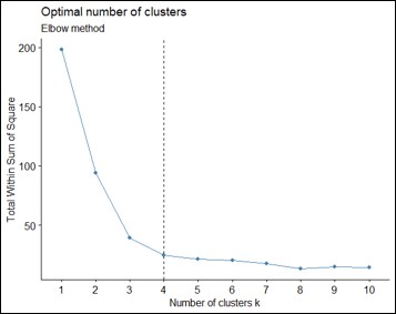
Fig. 4. Number of Clusters in Terms of K Means Method
Cluster Visulation
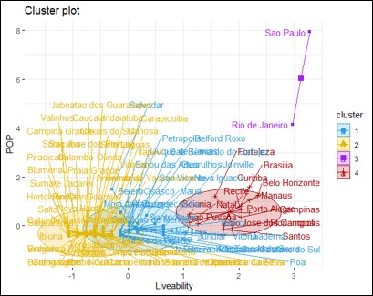
Fig. 5. Cluster Visulation In Terms Of K Means Method
Here are results for number of clusters and cluster visulation in terms of PAM in Figure 6 and Figure 7.
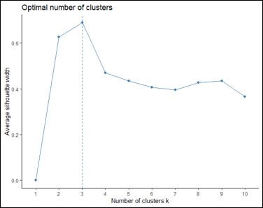
Fig. 6. Number of Clusters in Terms of PAM
Cluster Visulation
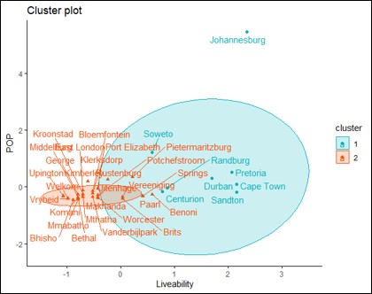
Fig. 7. Cluster Visulation In Terms Of PAM
Here are results for number of clusters and cluster visulation in terms of Clara method in Figure 8 and Figure 9.
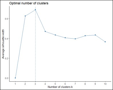
Fig. 8. Number of Clusters in Terms of Clara Method
Cluster Visulation
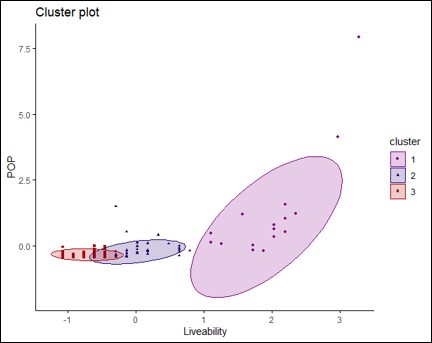
Fig. 9. Cluster Visulation In Terms Of Clara Method
As a result of all methods and agglomerations, the biggest cities has been emerged into two clusters, 4 main clusters has emerged for these dataset. On Table 2, clustering list of the cities has been given.
Table 2: Cluster List Of Brazil Cities
|
City |
Cluster |
Population |
|
Sao Paulo |
3 |
12300000 |
|
Rio de Janeiro |
3 |
6750000 |
|
Belo Horizonte |
4 |
2510000 |
|
Brasilia |
4 |
3020000 |
|
Manaus |
4 |
2220000 |
|
Porto Alegre |
4 |
1480000 |
|
Campinas |
4 |
1210000 |
|
Recife |
4 |
1650000 |
|
Curitiba |
4 |
1880000 |
|
Santos |
4 |
434000 |
|
Sao Jose dos Campos |
4 |
730000 |
|
Florianopolis |
4 |
478000 |
|
Fortaleza |
4 |
2450000 |
|
Joao Pessoa |
4 |
818000 |
|
Goiania |
4 |
1390000 |
|
Natal |
4 |
878000 |
|
Maringa |
1 |
436000 |
|
Niteroi |
1 |
497000 |
|
Sao Caetano do Sul |
1 |
162000 |
|
Vitoria |
1 |
356000 |
|
Santo Andre |
1 |
721000 |
|
Joinville |
1 |
598000 |
|
Nova Iguacu |
1 |
823000 |
|
Guarulhos |
1 |
1320000 |
|
Barueri |
1 |
262000 |
|
Sao Joao de Meritis |
1 |
473000 |
|
Maua |
1 |
453000 |
|
Diadema |
1 |
427000 |
|
Sao Bernardo do Campo |
1 |
844000 |
|
Jundiai |
1 |
402000 |
|
Itaquaquecetuba |
1 |
353000 |
|
Osasco |
1 |
695000 |
|
Duque de Caxias |
1 |
887000 |
|
Taboao da Serra |
1 |
294000 |
|
Sao Vicente |
1 |
356000 |
|
Belford Roxo |
1 |
513000 |
|
Mogi das Cruzes |
1 |
451000 |
|
Embu das Artes |
1 |
277000 |
|
Belem |
1 |
1500000 |
|
Francisco Morato |
1 |
168000 |
|
Poa |
1 |
114000 |
|
Atibaia |
1 |
137000 |
|
Mairipora |
1 |
100000 |
|
Franco da Rocha |
1 |
146000 |
|
Ribeirao Pires |
1 |
120000 |
|
Petropolis |
1 |
298000 |
|
Carapicuiba |
2 |
403000 |
|
Caieiras |
2 |
95800 |
|
Ferraz de Vasconceloz |
2 |
185000 |
|
Aruja |
2 |
83900 |
|
Salvodar |
2 |
2890000 |
|
Cotia |
2 |
230000 |
|
Itapevi |
2 |
223000 |
|
Itapecerica da Serra |
2 |
167000 |
|
Canosa |
2 |
348000 |
|
Vespasiano |
2 |
130000 |
|
Jandira |
2 |
126000 |
|
Varzea Paulista |
2 |
117000 |
|
Santana de Parnaiba |
2 |
127000 |
|
Cajamar |
2 |
71800 |
|
Campo Limpo Paulista |
2 |
80800 |
|
Cubatao |
2 |
132000 |
|
Contagem |
2 |
649000 |
|
Ananindeua |
2 |
540000 |
|
Viamao |
2 |
256000 |
|
Itanhaem |
2 |
96200 |
|
Guaruja |
2 |
311000 |
|
Nova Lima |
2 |
96200 |
|
Jaboatao dos Guararapes |
2 |
707000 |
|
Caxias do Sul |
2 |
517000 |
|
Olinda |
2 |
393000 |
|
Indaiatuba |
2 |
256000 |
|
Cachoeirinha |
2 |
118000 |
|
Sete Lagoas |
2 |
242000 |
|
Teresopolis |
2 |
184000 |
|
Embu-Guacu |
2 |
67300 |
|
Novo Hamburgo |
2 |
247000 |
|
Praia Grande |
2 |
299000 |
|
Itatiba |
2 |
123000 |
|
Jacarei |
2 |
235000 |
|
Caucaia |
2 |
369000 |
|
Sao Roque |
2 |
86500 |
|
Camaragibe |
2 |
155000 |
|
Braganca Paulista |
2 |
161000 |
|
Sao Jose dos Pinhais |
2 |
335000 |
|
Vinhedo |
2 |
72600 |
|
Bertioga |
2 |
64700 |
|
Valinhos |
2 |
120000 |
|
Colombo |
2 |
247000 |
|
Rio Claro |
2 |
200000 |
|
Cabo de Santo Agostinho |
2 |
209000 |
|
Ibiuna |
2 |
76400 |
|
Campina Grande |
2 |
405000 |
|
Salto |
2 |
114000 |
|
Sorocaba |
2 |
645000 |
|
Saquarema |
2 |
90600 |
|
Piracicaba |
2 |
391000 |
|
Blumenau |
2 |
362000 |
|
Sumare |
2 |
266000 |
|
Hortoloandia |
2 |
216000 |
4. Results
After statistical analysis, prior urbans were gathered on 3-4 clusters and >1.000.000 populated 1 no cluster cities. On Table 3 selected cities are listed below.
Table 3: Selected Cities Via Clustering Analyse
|
City |
Cluster |
Population |
|
Sao Paulo |
3 |
12300000 |
|
Rio de Janeiro |
3 |
6750000 |
|
Belo Horizonte |
4 |
2510000 |
|
Brasilia |
4 |
3020000 |
|
Manaus |
4 |
2220000 |
|
Porto Alegre |
4 |
1480000 |
|
Campinas |
4 |
1210000 |
|
Recife |
4 |
1650000 |
|
Curitiba |
4 |
1880000 |
|
Santos |
4 |
434000 |
|
Sao Jose dos Campos |
4 |
730000 |
|
Florianopolis |
4 |
478000 |
|
Fortaleza |
4 |
2450000 |
|
Joao Pessoa |
4 |
818000 |
|
Goiania |
4 |
1390000 |
|
Natal |
4 |
878000 |
|
Guarulhos |
1 |
1320000 |
|
Belem |
1 |
1500000 |
High-speed trains are currently the most competitive mode of passenger transport for distances between 400 and 600 kilometers. (HST). Air passenger transport is predominant on distances over 600 kilometers. Experiences and experiments in many Western and developed countries show that high-speed trains outperform road and air passenger transport at speeds of 200 km/h and above for distances of 400-600 km. (Kiziltas, 2020).
5. Discussion And Conclusions
Figure 10 shows metropolization and high capacity transport proposal map of Brazil.
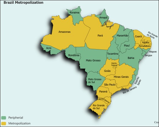
Fig. 10. Metropolization and High Capacity National Network Proposal Regions Map of Brazil
As shown in the map, the cities proposed for metropolization and high transport on this paper also include most of Brazil’s central natural, developing sustainable and densely populated areas. When these areas are equipped with high-speed trains, a robust planning, high capacity transport and inter-city transportation, a metropolization core and agglomeration will be created in the country's geographically significant and strategic areas. On the other hand, with the completion of all these planning’s and projects, national robust integration and north-south high degree connection will be provided.
Metropolitanization can occur in the form of sub-regionalization, regionalization, polycentric development, monocentric development, and urban core formation thru the convergence of two centers. In all of these, the establishment of a transportation network is either a cause or an effect. However, especially rapid transportation, triggers and develops these centralization processes. At this point, the question arises of which rapid transit network reinforces what kind of metropolitanization. This is also an issue that has been the subject of ongoing research. Emphasizing metropolitanization is an advanced step toward nationalization for both developed and developing countries. Beyond national unity, it also supports regional integration.



Open Access By Aditum Open Access Journals id licensed under Creative Commons Attribution 4.0 International License. Based On a Work at aditum.org


