
International Journal of Business Research and Management
OPEN ACCESS | Volume 5 - Issue 2 - 2026
ISSN No: 3065-6753 | Journal DOI: 10.61148/3065-6753/IJBRM


Mehmet Çağrı Kızıltaş1*, Merve ÖZTÜRK2
1Department of Civil Engineering, Faculty of Engineering and Architecture, Istanbul Beykent University.
2Department Of Political Sciences and Public Administration, Faculty of Economics and Administrative Sciences, Batman University.
*Corresponding Author: Mehmet Çağrı Kızıltaş, Department of Civil Engineering, Faculty of Engineering and Architecture, Istanbul Beykent University.
Received: September 15, 2026 | Accepted: September 26, 2026 | Published: October 02, 2026
Citation: Mehmet Ç Kızıltaş, ÖZTÜRK M., (2026). “An Analysis of National Integration via Clustering on Korea (South and North) for an Infrastructural Position”. International Journal of Business Research and Management 5(2); DOI: 10.61148/3065-6753/IJBRM/103.
Copyright: © 2026. Mehmet Çağrı Kızıltaş. This is an open access article distributed under the Creative Commons Attribution License, which permits unrestricted use, distribution, and reproduction in any medium, provided the original work is properly cited.
The most important part and driving force of Korean National Integration is the integration of transportation infrastructure. The most effective tool of today's transportation infrastructure is high-speed, high-comfort intercity mobility. The key to this is sustainability, urbanization, and advanced technology. On this paper, a cluster-oriented solution was conducted for South Korea by using of population, GDP and city liveability by cluster focused statistical equations. Recommendations were given in line with competitive operating ranges of high-speed transport between specified cities and regions. As a result, suggestions were shared.
National integration, metropolitan, infrastructure, destinations, cost
1. Introduction
Korea was divided into North and South in 1945. In 1948, it was officially established as two separate states. These are the Democratic People's Republic of Korea and the Republic of Korea. Between June 25, 1950, and July 27, 1953, the Korean War took place, and the division deepened further. Located in the southern part of the peninsula, South Korea, despite having a smaller land area, hosts a much denser population. The country's total area is 97,230 square kilometers, and Worldometer South Korea Data shows that its current population is approximately 51.6 million. This situation makes the country one of the regions with the highest population density in the world.
At the forefront of South Korea's most important cities is the massive capital, Seoul, which, along with its surrounding metropolises, houses nearly half of the country's population. In addition to Seoul, the country's largest port city and trade center, Busan, Incheon, which is an important industrial and port hub, Daegu, known for its cultural and economic significance, and Daejeon, which stands out for its high-tech investments, are among the other critical metropolises. North Korea, which covers the northern part of the peninsula, has a larger geographical area compared to its neighbor but a smaller population. The country's total area is 120,410 square kilometers, and its current population is approximately 26.6 million according to Worldometer North Korea Data. In the country, which has vast mountainous terrains, the population density is much lower compared to South Korea.
The administrative, cultural, and economic heart of North Korea is the capital city of Pyongyang, which is by far the most developed and largest city in the country. Among the other important centers outside the capital are Hamhung, one of the country's largest industrial and port cities, Sinuiju, which has strategic commercial importance due to its proximity to the Chinese border, Chongjin, another significant coastal industrial center, and Kaesong in the south, known for its historical ties. South Korea has one of the most developed and integrated transportation networks in the world. The backbone of intercity transportation is formed by the high-speed train network called KTX (Korea Train Express). This system, which connects the capital city of Seoul to major cities across the country such as Busan, Mokpo, and Gangneung at speeds exceeding 300 kilometers per hour, has reduced intercity distances to just a few hours. In addition to the railroad, the advanced highway network that spans the entire country and the intercity busses (Premium/Express Bus) that operate in the luxury segment offer comfortable and punctual alternatives to train lines.
In urban transportation, the highest level of technology and innovation is evident. Primarily, the metro systems in major cities such as Seoul, Busan, Daegu, and Incheon are considered among the best in the world due to their punctuality, cleanliness, and multilingual information screens. City bus routes are optimized with color codes (blue, green, red) to completely cover areas without a subway. Integrated smart cards like "T-money" are used for urban travel; with these cards, transfers from the subway to the bus are free or significantly discounted. North Korea's transportation infrastructure is largely based on technologies from the Soviet era and a railway-centric system. Approximately 80% of intercity passenger and freight transportation is carried out by the state-operated electric railroad network. However, due to energy shortages, power outages, and inadequate infrastructure, train services frequently experience delays. Although there are highways that traverse the country, intercity roads are generally used by military vehicles, official personnel, and freight trucks due to the very low rate of private vehicle ownership and fuel restrictions.
In urban transportation, the capital city Pyongyang is in a quite privileged position compared to the rest of the country. With its deep tunnels and magnificent chandeliers, the historic Pyongyang Metro, resembling an underground palace, bears a significant burden of the city's traffic. In the capital, trolleybuses, trams, and double-decker busses also provide extensive service to support the metro line. In other North Korean cities, public transportation options are quite limited; the people mostly walk or use bicycles for urban and short-distance travel.
Multi-sectoral improvement is a challenging issue, especially for developing countries. And the mentioned countries strengthen their core sectors such as construction, healthcare, tourism, heavy industry, infrastructure, energy, military, or light industry. The driving force behind tourism is a well-developed transportation system. High-speed systerms and well planned urban clusterings are important asset, capacity, and opportunity for national based tourism.
Korea is among the countries with the oldest history in the world. Korea in East Asia has ethnolinguistic ties with peoples such as the Mongols, Manchus, Turkic peoples of Asia, and the Japanese. South Korea has an area of 100.363 km2 and a population of 51,641,642 as of the end of 2025 (Worldometer, 2025). A large portion of the Korean population is ethnically Korean. The country was divided into South and North in 1948, immediately after World War II. Between 1950 and 1953, there was a major war and destruction between North Korea and South Korea, reaching international dimensions and motivated by the Cold War. There is also a Turkish population in South Korea dating back to those war years. North Korea's population is 26.606.699 and its land area is 120.540 km2 (Worldometer, 2025). The integration of the two countries is an important issue, but there is currently no such political possibility. In South Korea, over half the population is atheist, while in North Korea, this figure reaches 73%. In South Korea, 15% of the population is Buddhist, while in North Korea, 12% are Shamanist. Additionally, 27% of South Koreans are Christian (İnsamer Ülke Profili Güney Kore, 2025). The Korean Peninsula is bordered by China's Manchuria region to the north. Its sea neighbor is Japan.
Development of the region will start with integration, which is strongly bounded to infrastructural and metropoliten integration and advancement. Within the scope of this study, cities of South Korea were listed in terms of parameters like population, livability indexes and gross domoestic products (GDP’s), and were issued to clusterings calculations with usage of statistical calculate types on the R Studio program. On this parallel, priority and important urbans were specified by determining the number of clusters and cluster lists that expressed rely on the most adaptable cluster method. The aforementioned priority cities were re understood and analyzed rely on operate distance, and lastly accessed to a high-speed mobiltiy system proposal and metropolization roadmap for United Korea.
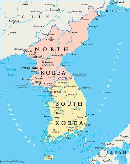
Fig. 1. Big Urbans of Korea Map (World Map, 2025)
North Korea, Manchuria Region (China), Amur (Russia), Kamchatka (Russia), Japan, Vietnam, Philippines and Thailand are significant parts of this mentioned region. The total of all of the called nations substitute a quite huge land area with their various important sources, population, population density, cultural variety, urban developing and efficient geographical conditions too. And addition to all of these, there are some significant and large islands around this mentioned and specified region on Pacific Ocean too.
This region also has a neighborhood with far Asia, especially with China, east Russia, Asia Pacific islands and Vietnam as a whole manner. So the cultural, geographical and social features of this area are quite deep and enough rich. This composition and photo could be meaningful with detailed mapping. This mentioned geography has a high priority and urgency for integration and development because of strategical conceptual.
In Figure 2 South Korea state map is presented (BBC Asia Pacific, 2025). Figure 3 shows South Korea Geographical Map (Worldometers Info, 2025). Table 1 shows South Korean cities’ populations, liveabilities and GDP’s (OECD, 2020).
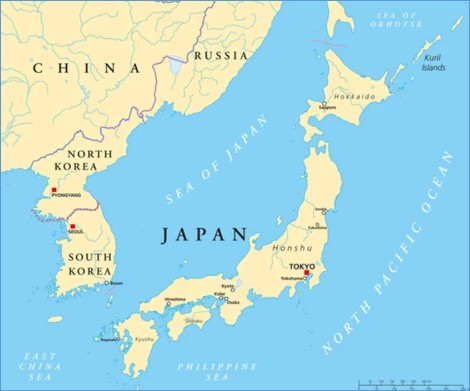
Fig. 2. Korea State Map (BBC Asia Pacific, 2025)
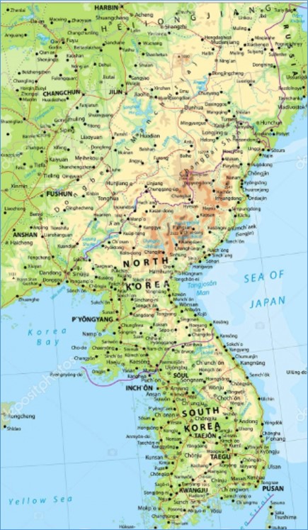
Fig. 3. Korean Geographical Map (Worldometers Info, 2025)
Table 1: South Korean Cities Populations, GDP’S And Liveabilities (Oecd, 2020)
|
City |
GDP |
Population |
Liveability Index |
|
Seoul |
1068311 |
23736409 |
94 |
|
Gimhae |
150935 |
4454748 |
73 |
|
Dalseong |
64228 |
2387450 |
72 |
|
Gwangsan |
51429 |
1547046 |
72 |
|
Seo |
48872 |
1449628 |
75 |
|
Seongsan |
42108 |
1092468 |
66 |
|
Ulsan |
61736 |
902534 |
72 |
|
Heungdeok |
46220 |
879406 |
69 |
|
Deokjin |
25928 |
745770 |
68 |
|
Sebuk |
41273 |
655292 |
67 |
|
Gyeongsan |
13179 |
264627 |
68 |
|
Pohan |
22276 |
501058 |
71 |
|
Gumi |
26008 |
526330 |
66 |
|
Jeju |
12034 |
489241 |
64 |
|
Jinju |
13291 |
346380 |
69 |
|
Wonju |
12772 |
354049 |
65 |
|
Iksan |
9664 |
278554 |
67 |
|
Chuncheon |
10932 |
281862 |
70 |
|
Gunsan |
8309 |
264798 |
67 |
|
Suncheon |
14108 |
280802 |
67 |
2. Literature Review
Incheon International Airport, South Korea's gateway to the world and a global transfer hub, is the center of air travel. The AREX train line, which operates continuously between Seoul and Incheon Airport, greatly facilitates passengers' access to the city. In domestic air transportation, the route between Seoul (Gimpo) and the tourist paradise Jeju Island hosts the world's busiest domestic flight traffic. Additionally, regular ferry services are operated from massive port cities like Busan and Incheon to surrounding islands and international destinations. In North Korea, international transportation and connections to the outside world are conducted through extremely limited channels. The country's international air traffic is provided by the state airline Air Koryo through the Pyongyang Sunan International Airport in the capital, and flights are primarily made to limited destinations such as Beijing and Vladivostok. The country's most active physical connection with the outside world is the railroad and highway that pass over the "China-Korea Friendship Bridge," which connects the city of Dandong on the Chinese border with Sinuiju.
As a developing region on this context, the spread of well-planned metropolization and high standard transportation in Italy is an important saving. At the center of all of this, there are well planning, detailed analysis and true approaches (Givoni, 2006).
3. Methodology
Clustering Analysis
Clustering statistical analysis have been conducted via K means method, PAM and Clara method.
Here are results for number of clusters and cluster visulation in terms of K means method in Figure 4 and Figure 5.
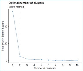
Fig. 4. Number of Clusters in Terms of K Means Method
Cluster Visulation
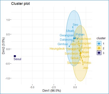
Fig. 5. Cluster Visulation in Terms of K Means Method
Here are results for number of clusters and cluster visulation in terms of PAM in Figure 6 and Figure 7.
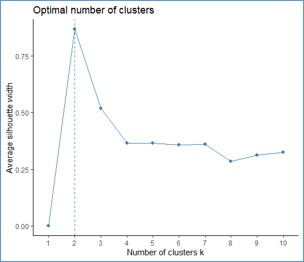
Fig. 6. Number of Clusters in Terms of PAM
Cluster Visulation
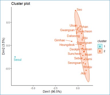
Fig. 7. Cluster Visulation in Terms of PAM
Here are results for number of clusters and cluster visulation in terms of Clara method in Figure 8 and Figure 9.
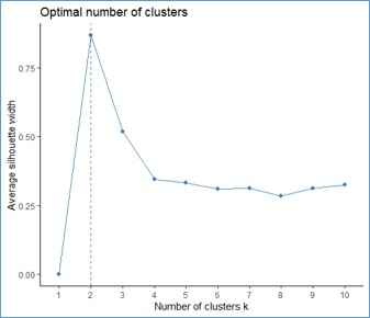
Fig. 8. Number of Clusters in Terms of Clara Method
Cluster Visulation
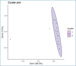
Fig. 9. Cluster Visulation in Terms of Clara Method
As a result of all methods and agglomerations, the biggest cities has been emerged into three clusters. On Table 2, clustering list of the cities has been given.
Table 2. Cluster list of south korean cities
|
City |
GDP |
Population |
Cluster |
|
Seoul |
1068311 |
23736409 |
3 |
|
Gimhae |
150935 |
4454748 |
1 |
|
Dalseong |
64228 |
2387450 |
1 |
|
Gwangsan |
51429 |
1547046 |
1 |
|
Seo |
48872 |
1449628 |
1 |
|
Seongsan |
42108 |
1092468 |
2 |
|
Ulsan |
61736 |
902534 |
1 |
|
Heungdeok |
46220 |
879406 |
2 |
|
Deokjin |
25928 |
745770 |
2 |
|
Sebuk |
41273 |
655292 |
2 |
|
Gyeongsan |
13179 |
264627 |
2 |
|
Pohan |
22276 |
501058 |
1 |
|
Gumi |
26008 |
526330 |
2 |
|
Jeju |
12034 |
489241 |
2 |
|
Jinju |
13291 |
346380 |
2 |
|
Wonju |
12772 |
354049 |
2 |
|
Iksan |
9664 |
278554 |
2 |
|
Chuncheon |
10932 |
281862 |
2 |
|
Gunsan |
8309 |
264798 |
2 |
|
Suncheon |
14108 |
280802 |
2 |
4. Results
After statistical analysis, prior urbans were gathered on 3-1 numbered clusters. On Table 3 selected cities are listed below.
Table 3. Selected cities via clustering analyse
|
City |
GDP |
Population |
Cluster |
|
Seoul |
1068311 |
23736409 |
3 |
|
Gimhae |
150935 |
4454748 |
1 |
|
Dalseong |
64228 |
2387450 |
1 |
|
Gwangsan |
51429 |
1547046 |
1 |
|
Seo |
48872 |
1449628 |
1 |
|
Ulsan |
61736 |
902534 |
1 |
|
Pohan |
22276 |
501058 |
1 |
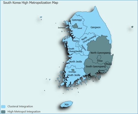
Fig. 10. Metropolization Map of South Korea
The cities and urban areas selected above are regions that exhibit South Korea’s highest level of metropolitanization and are trending towards producing the most advanced life mobility. Rely on the leading role these cities are going to play in region’s economic, social, urban, and technological life in the short term, it is significant and a priority for region to be linked by a high-speed, high-capacity, and high-comfort inter urban connection. The emergence of the high-speed linkage are going to also substitute one of the new kilometer stone of the national and trans nation regional transportation framework. On the other hand, constituting of a new high-capacity-high-comfort Transportation route based on determined cities and regions are going to play an important and reliable role on near and middle future integration improvements for South Korea, North Korea, Manchuria (China) and Amur (Russia) too.
Key indicators of toay’s mobility dynamics are high speed railways, Maglev trains, airway passenger transport and highway passenger transport. But for 400-600 km distances the best one ise high speed raileways. For 600-800 km distances, the best one is Maglev trains (Kiziltas, 2020).
South Korea is one of the world leaders in railroad technology, and the heart of the country's high-speed train network is the KTX (Korea Train Express) system. Launched in 2004 and based on French TGV technology, the KTX has been fully localized over time, transforming into entirely Korean-made trains with the KTX-Sancheon and the new generation eco-friendly KTX-Eum models. These trains, which reach an operational speed of 305 kilometers per hour, have reduced the travel time between Seoul and Busan, the country's busiest corridor, to under 2.5 hours. Another high-speed line supporting the KTX network is the SRT (Supreme Railroads) trains, which depart from the Suseo station south of Seoul and reach speeds of 300 kilometers per hour.
There is no high-speed train (HST) line or technology in North Korea that meets today's standards. The country's railroad infrastructure is based on technologies built with the support of the Soviet Union and China in the mid-20th century. Although the armored green train used by North Korean leader Kim Jong-un during his official visits to the outside world is the country's most well-known railroad vehicle, this train can only move at a speed of around 50-60 kilometers per hour due to security measures and infrastructure inadequacies. Although the government has expressed intentions to modernize the railroads and integrate them with neighboring countries, the current economic sanctions and resource shortages make high-speed train investments impossible.
Along with emerging technology, there are many alternative modes of transportation that provide high-quality service at high inter-city speeds. These can be classified as magnetically driven trains (Maglev), high-speed trains, airlines, high-comfort road transport. These modes of transport are highly competitive in cross-city travel, but their interconnections are combined or isolated accordingly (Marta et al, 2010).
5. Discussion And Conclusions
In South Korea, the proposed high-speed mobility national network resulting from the analysis constitutes the most important step and backbone of the unification of North and South Korea. The integration of the national transportation networks of South Korea and North Korea is the most fundamental step in Korean unification. At this point, the infrastructure advantage clearly lies with South Korea. Therefore, the integration of the Korean National Infrastructure can be achieved by extending South Korea's transportation network to North Korea.
As shown in the Figure 10, the urbans proposed as a result of deep analysis in this paper are focused generally in coastal areas, South and Southeast parts of the country. These are main centers for integrating and unity of South Korea and peripherial. These area is not near to North Korea, it is on the vicinity of seaside and Japan. Seoul and Gwangju are city centers apart from south east coastal central area and they have unique properties.



Open Access By Aditum Open Access Journals id licensed under Creative Commons Attribution 4.0 International License. Based On a Work at aditum.org


