Agricultural Research Pesticides and Biofertilizers
OPEN ACCESS | Volume 6 - Issue 1 - 2026
ISSN No: 2994-0109 | Journal DOI: 10.61148/2994-0109/ARPB


Dereje Mosissa1*, Dejene Reda1 and Melak Agajie2
1Ethiopian Biodiversity Institute Assosa Biodiversity Center, Forest and Rangeland Biodiversity Case Team, Assosa, Ethiopia
2Ethiopian Biodiversity Institute Assosa Biodiversity Center, Crop and Horticulture Biodiversity Case Team, Assosa, Ethiopia
*Corresponding Author: Dereje Mosissa, Ethiopian Biodiversity Institute Assosa Biodiversity Center, Forest and Rangeland Biodiversity Case Team, Assosa, Ethiopia.
Received: June 03, 2021
Accepted: June 14, 2021
Published: June 21, 2021
Citation: Mosissa.D, Reda.D and Agajie.M. (2021) “Biophysical Characterization of Mima Model Water Shade of the Benishangul Rional State, Ethiopia: A baseline Tool for Planning, Implementation, and Evaluation.”, Journal of Agricultural Research Pesticides and Biofertilizers, 2(1); DOI:http;//doi.org/06.2021/1.1026.
Copyright: © 2021 Dereje Mosissa. This is an open access article distributed under the Creative Commons Attribution License, which permits unrestricted use, distribution, and reproduction in any medium, provided the original work is properly cited.
The Mima water shade covers an area of 1031hactar and the Mima water shade is one of the main streams draining into Afa River. The water shade is found at the distance of 24kms from Assosa town on the way to Addis Ababa through Bambasi District of Benishangul Gumuz Regional State. Baseline data was collected for biophysical (vegetation) parameters. The baseline data collection is built around seven transects by the use of blocks of 10 m2 in size. Hence, in each block the sampling size is 54 plots. This baseline assessment presents the results of the data collected from the combination of field and on farm surveys in three blocks of the Mima water shade. Interpretation and management recommendations are based solely on the data and do represent a consensus view between the project and the survey results. It is imperative that before initiating any activities in the respective blocks, more information be collected for the targeted area chosen for interventions. The result of the evaluation showed that the water shade is poorly contained in its both physical and biological structures. However, the surrounding environment specially the border to south of the water shade commonly known as Anbessa Forest is an opportunity to enrich the water table and biodiversity of the water shade. It should be noted that recommendations made within this report are not based on any dialog with communities. It is therefore vital for the Project to establish a dialog with the target communities and farmers. These communities and farmers need to be actively involved in the process of prioritizing activities. Thus, the information contained within the report should provide support to the field officers of Mima model water shade, but the ultimate decisions concerning priorities need to be made based upon consensus between the communities and the Project.
The Mima water shade covers an area of 1031hactar and the Mima water shade is one of the main streams draining into Afa River. The water shade is found at the distance of 24kms from Assosa town on the way to Addis Ababa through Bambasi District of Benishangul Gumuz Regional State. It is bordered by Amba 16 kebele to west and Jematsa kebele to east direction. Mima water shade is bounded by longitudes 34°39’ east and latitudes 9°55’ south. The central point of the water shade is transversed by Longitude 34°40’ East and Latitude 9°56’ S (Figure 1).
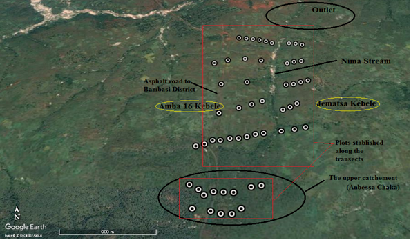
Figure 1: Map of Mima water shade
The survey team has identified three main areas in the Mima water shade in which activities will take place. These focus areas (or “blocks”) have been identified from ground surveys and satellite images and have been placed to represent the water shade in terms of species diversity (vegetation) and land use: the upper catchement (block) is located in an Anbessa Chaka (Forest) area with high plant species density and higher elevation; the Middle half water shade (block) is the one to Jematsa kebele further upslope characterized by medium elevation, moderate to steep slopes and with mostly abandoned areas and finally, the middle half water shade (block) in Amba 16 kebele is characterized by larger farms and medium elevation.
Baseline data was collected for biophysical (vegetation) parameters. Before commencing the baseline data collection, the local administration was informed of the project and a series of meeting arranged in each of the sub-locations where sampling was to take place by the project hosting institute (i.e EIAR). EIAR and other stalk holders jointly hold these meetings, where the overall objectives of the project were outlined and discussed.
The baseline data collection is built around seven transects by the use of blocks of 10 m2 in size. The basic sampling unit is called a plot. In each block, different points are generated from which 13, 16 and 25 sampling plots that constitute the cluster are generated. Hence, in each block the sampling size is 54 plots (see figure 2). The centre point of each cluster is randomly placed within each block. The sampling plots are then randomized around each cluster center point, resulting in a spatially stratified sampling design. This sampling design ensures proportional sampling within each block and minimizes local biases. The randomization procedures are done using either customized programs or scripts or a special Microsoft Excel spreadsheet that has been prepared for this purpose. Using these tools enables easy up-load of plot coordinates to GPS units, which are then used to navigate from sampling plot to sampling plot in the baseline data collection exercise. For more detailed information about the randomization procedure see Annex 1.
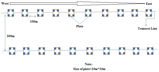
Figure 2: Schematic representation of transects laid and plots sampled
Biophysical (vegetation) information is collected for each of the 54 sampling plots for the three clusters (blocks) established. The biophysical team collects information on status of soil erosion, land cover, agroforestry practice, and species. Before sampling can begin, the sample plot needs to be laid out.
Upon reaching the sampling plot, a square arm plot method is used in setting up the plot layout as described on figure 2. This method allows vegetation to be sampled and classified for an area of 1000m2. After identifying the points an additional vegetation data such as species habit and status was recorded. Once the plot layout is set-up, sampling can begin.
2.Data collection:
The field data recording sheet is given in Annex 2. The recording sheet is divided into six sections, A-F:
Section A: First, the centre point location is geo-referenced using a GPS unit. All the GPS data were recorded on section A.
Section B: Second, the major landforms and the topographic position are described. To do this, the surrounding area is inspected and the appropriate categories, provided on the field data recording sheet, are selected.
Section C: Thereafter, the land cover for all the plots is recorded using the FAO Land Cover Classification System (LCCS). This classification system recognizes 8 primary land cover types of which 5 are present in the study areas of Nima water shade: Cultivated and managed terrestrial areas, natural and semi-natural vegetation, cultivated aquatic or regularly flooded areas, natural or semi-natural aquatic or regularly flooded vegetation, and bare areas. The LCCS classification system allows the identification of different land cover types on the basis of the dominant vegetation type (tree, shrubs, herbaceous). The questions in the field data recording sheet are designed to guide one through the classification process.
Section D: In section D, we collect information regarding land use and land ownership.
Section E: Section E is for physical characterization of the soil surface. The first questions are on erosion and conservation practice.
Section F: Woody vegetation is measured in this section using the T-square sampling method. This method is one of the most robust methods for sampling woody plant communities. It can be used to estimate stand parameter such as density. The advantage of this method is that it is less prone to bias where plants are not randomly distributed, such as in managed landscapes (Anbessa Forest/Chaka). In this sampling scheme, trees and shrubs are sampled separately.
The frequency gives an approximate indication of the homogeneity or heterogeneity of an area. The high values or low value in frequency class A/B and low value in D/E indicates a constant or similar species composition. On the other hand, higher value in lower frequency class and lower value in higher frequency class indicates a higher degree of floristic heterogeneity (Lamprecht 1989)
The frequency of plant species recorded in each plot was determined by using a formula:
f=nPtPx100
The population of the area is known to have both Berta and Amhara. The area is largely subsistence farming today with a mix of crops typical of the lower elevations of western Ethiopia. Maize, Soya bean and sorghum are the major crops; Avocado, Lemon, Kashmir, Orange and banana are also grown. The area is also an important producer of mangos.
The upper catchment of Mima water shade is bordered by Amba 16 to northwest, Jematsa kebele to east and portion of Anbessa chaka to south and is generally characterized by moderate to steeply sloping terrain with slopes ranging between 1 and 35%. The northern part of the block (catchment) has a few large hills, notably the hill in the northwest corner of the Anbesa Chaka (block) (Figure -). The central and southern parts of the block have a rolling terrain. The Mima stream traverses the upper block from the northeast to the west. The block is dissected by a number of important tributaries of the Mima stream.
Around 35% of block area is hilly with slopes of greater than 5%. The areas around plot 1, 2, 3, 4, 5, 6, 7, 8, 9, 10, 11 and, 12 are hillier, with slopes exceeding 10%. The eastern part of the block also has more sloping land with 30 to 40 percent of the plots in clusters 14 and 15 exceeding 10% slope. The remaining plots fall on the Mima stream flood plain.
Forest is the major land-use and drives land cover in the upper catchment (block) (Table 1; Figure 3). The area is dominated by Combretum_Terminalia woodland and perennial grasses for livestock grazing. There are also areas of woodland along the Mima stream and its tributaries. The second most common vegetation type was grasslands. Natural grass species includes both perennial and annual both palatable and unpalatable for livestock. The dominant species in the area are:
|
Vegetation strata |
No. points |
Percentage |
|
Fallow/Abandoned |
28 |
17.5 |
|
Farmland |
73 |
45.6 |
|
Forage land |
9 |
5.6 |
|
Other |
1 |
0.6 |
|
Perennial grassland |
36 |
22.5 |
|
Wood land |
13 |
8.1 |
Table 1: Land cover classification (N=54).
The largest portion of land in this catchment (block) falls under protected area however, there was massive grazing by livestock. The area used for food production was somewhat less. Notably, food production was largely absent in plot 1-14, but grazing was the dominant land use in these plots. A small percentage of the land was used primarily for producing wood.
In general, there are many natural trees in the landscape. A few woodlots or planted plantations (Eucalyptus) were found during the survey. Of the 26 plots sampled on the upper catchment (block) only 73% or 19 plots were abundantly covered by trees in the vicinity. This woody vegetation is mostly broadleaf and deciduous, (Table 2).
|
Species |
Family |
Local Name |
|
Albizia malacophylla |
Fabaceae |
Kender/Sesiye/Mukie |
|
Annona senegalensis |
Annonaceae |
Adegella/Gishta |
|
Breonadia salicina |
Rubiaceae |
Digil |
|
Combretum collinum |
Combretaceae |
Sistsia Begneni/Abalo/Weyiba |
|
Combretum molle |
Combretaceae |
Kushmindari/Key Abalo |
|
Cordia africana |
Boraginaceae |
Abanga/Wanza |
|
Croton macrostachyus |
Euphorbiaceae |
Bisana |
|
Dombeya aethiopica |
Sterculiaceae |
Fodok/Wulkeffa |
|
Entada africana |
Fabaceae |
Dirtsign/Geri |
|
Erythrina abyssinica |
Fabaceae |
Amblish/Korch |
|
Ficus sychromus |
Moraceae |
Babekel/Sholla |
|
Ficus sur |
Moraceae |
Gansha/Sholla |
|
Gardenia ternifolia |
Rubiaceae |
Aqenda/Gambelo |
|
Lannea fruticosa |
Anacardiaceae |
Etsiya Urubo |
|
Lannea welwitschii |
Anacardiaceae |
Qua |
|
Oxytenanthera abyssinica |
Poaceae |
Kagu/Qerqeha |
|
Piliostigma thonningii |
Fabaceae |
Megel/ Yekolla wanza |
|
Protea sp |
Protiaceae |
Chedeber |
|
Maytenus senegalensis |
Celastraceae |
Nech atat |
|
Maytenus undata |
Celastraceae |
Gram atat |
|
Rhus vulgaris |
Anacardiaceae |
Silkela/Ashqamo |
|
Securidaca longepedunculata |
Polygalaceae |
Sheqet/Tsemenay |
|
Stereospermum kunthianum |
Bigniniaceae |
Aqulqa/Zana |
|
Syzygium guineense subsp. afromontanum |
Myrtaceae |
Bulmetse/Yewenz Dokma |
|
Syzygium guineense subsp. macrocarpum |
Myrtaceae |
Anzu/Dokma |
|
Terminalia laxiflora |
Combretaceae |
Hori/Baguri/Qorasum/Akuma |
|
Terminalia macroptera* |
Combretaceae |
Kebugir/Avalo |
|
Vitex doniana |
Lamiaceae |
Atsoda/Ququra |
|
Ximenia americana |
Olacaceae |
Bebe/Enquay |
|
Ziziphus abyssinica |
Rhamnaceae |
Merqeqo/Yeneber Tifir |
Table 2: List of trees recorded in the upper catchment (block)
The woody vegetation present in this area is broadleaf and deciduous. Oxytenanthera abyssinica, Albizia malacophylla, Combretum colinum, and Terminalia laxiflora was the tree most commonly encountered. Terminalia brownii, Ziziphus abyssinica and Cordia africana were also commonly seen. There was a wide variety of shrubs encountered including Rhus vulgaris, Rhus glutinosa, Vernonia purpurea, Flugea vilosa, and Acanthus polystachius. Shrubs were widely present in the landscape and were measured on 82% of the plots. Few exotics trees and herbs were found on the plots sampled. Eucalyptus spp., Grevillea robusta and Striga harmonicawas widespread in some block indicating low soil fertility.
|
Broadleaf |
Allophytic |
Deciduous |
Evergreen |
|
83.8 |
0.1 |
84.3 |
0.9 |
Table 3: Wood vegetation type (% of plots with vegetation types present)
This area (block) is one of the sources of Nima stream and its tributaries. However, the greatest amount of biomass loss occurs in the upper catchment (Block), particularly along the transect line three because of massive grazing and resource exploitation by the nearby villagers. Fodder supply and quality is important a problem in this area as it is elsewhere. Free grazing is a major problem in the entire block and is a threat to the upper catchment and tree plantation activities. The project should therefore assist the communities in setting-up by-laws to control free-grazing and promote live fencing. It is imperative that free grazing is controlled for the project to have any impact in terms of tree planting and rehabilitation of degraded areas. Several Acacia species can be planted as live fences since they are tolerant to browsing. Establishment of fodder banks and the encouragement of hay production might also be considered with communities. If farmers begin controlling grazing, an alternative fodder source needs to be provided. Planting trees at wide spacing (e.g. 4 x 10 m) on degraded sites would allow for both wood and grass production, where the grass could be used to augment fodder availability for farmers.
Another option that needs to be explored with communities is intercropping food crops with a legume that can also be used as animal feed. This area should be the focus for land rehabilitation work. Elsewhere in the block, soils are degraded, but still cultivated. These areas should be targeted for soil conservation and development of area enclosure systems that maintain more permanent vegetative cover. Additional erosion and hard setting on these sites could render them unfit for underground water holding.
Interventions in this block should mainly focus on soil conservation and increasing vegetation cover, boosting soil fertility and enhancing biodiversity. Deforestation, massive grazing and hard setting is a major problem in this block and baseline data shows severe land degradation in the entire block, except for the river valleys. Hence, activities which halt the degradation of wetland areas and tributary streams that are still being threatened should be given priority. The Project should also promote rehabilitation of degraded areas, particularly in the upper portion of the block where the Mima stream begins its birth for the water shade under priority. Such activities should include forest enrichment through tree planting, control of over resource exploitation and free grazing.
The areas adjacent to the tributaries of the Mima stream need to be stabilized and interventions set up should be done to protect the riverbanks. Finally, establishing and strengthening of community groups should also be an activity of the project.
The Middle block is located in both Jematsa and Amba 16 kebeles of Bambasi Districts. The block contains twenty-eight sub-locations (plots) as well as the Anbessa forest (Figure 3).
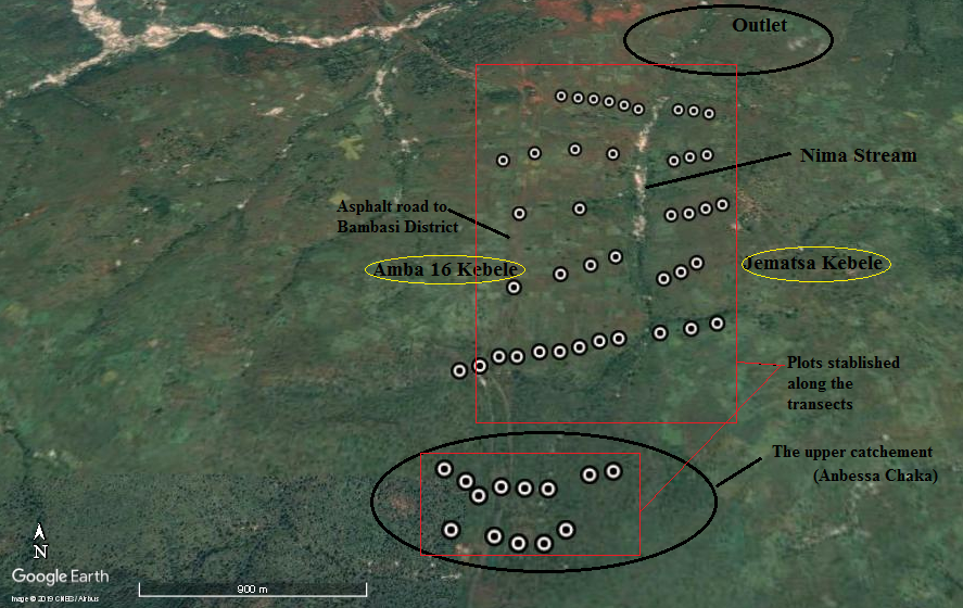
Figure 3: Aerial photograph showing Mima water shade and transects laid
The landscape consists of mountainous highlands in the southern part of the block, with numerous small streams and clusters of wetlands. In the south-eastern part of the block, the Anbessa forest is located where logging is taking place and the forest reserve is being used for cultivation. Throughout the block there are remnant forests which are used for grazing and shifting cultivation including in Anbessa forest. These forests are preserved but are accessible by the communities illegally for agricultural expansion, grazing, wood and firewood supply. The conversion to agriculture took place since in the 1990s. Today the majority of the farms are over utilized, and few farms are practicing the traditional rotations with periodic fallows.
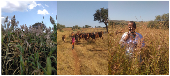
The Mima stream borders the Jematsa block into the eastern parts. The northern part of the water shade (block) is characterized by better farming practices and fewer presences of trees in the landscape. The major food crop is sorghum. In this area all farms have hedges along the farm boundaries and more animals are seen to graze freely (Figure 4).
The southern part of the block is characterized by poor farming practices with cultivation of steep slopes without conservation measures.
Figure 4: Some of common land uses in the eastern block (Jematsa Kebele)
In this area, a very few trees are seen in the landscape and few land owners have demarcated their farms. The area to the south of Jematsa kebele (eastern block) is part of the Anbessa forest reserve, however, all trees have been cut and the area is converted to a new agricultural land which is the indication to the practice of shifting cultivation, with scattered patches of grasses present (Figure 3). The farms observed in this area are not well managed, contrary to the western block (Amba 16) part of the block where the sorghum is well established and managed.
2.1.3. Bio physical baseline data summary:
1.Topography:
The area of eastern block (Jematsa Kebele) is made up of plateau tilting towards the Mima stream with numerous few streams and clusters of wetlands following the streams and Anbessa forest.
2.Vegetation and land use:
Farming is the major land-use and drives land cover in the eastern bloc (Jematsa Kebele) (Table 4; Figure 3). Agriculture is dominated by sorghum, soya beans, teff, and nug (guzotia abyssinica).
|
Vegetation strata |
No. points |
Percentage |
|
Farm land |
22 |
77% |
|
Free grazing |
14 |
3% |
|
Perennial grassland |
3 |
9% |
|
Farrow |
13 |
2% |
|
Plantation / forest |
1 |
4% |
|
Other |
1 |
5% |
Table 4: Land cover classification (N=54)
The second most common vegetation type was grasslands and farrow/abandoned area. Some remnant forests are also seen around the block bordering Anbessa forest. The woody vegetation found in these forests has been assessed and annexed at the end of this document. The Anbessa forest, which is located in the proximity of Nima water shade is the only forest left in the area. A classification of the primary current land use showed the following:
Generally the woody vegetation is broadleaf and deciduous (Table 5). An assessment of the trees in the landscape shows that of the 160 sampled plots only 53 (33%) had trees in the vicinity. Plots for which more than half of the sampled plots had trees in the vicinity were 5, 7, 9, 11, 13 and 14.
|
Broadleaf |
Needle leaf |
Allophytic |
Evergreen |
Deciduous |
|
68.1 |
0.0 |
3.1 |
1 |
53.1 |
Table 5. Woody vegetation type (% of plots with vegetation types present)
The following species were seen in the landscape: Oxytenanthera abyssinica, Cordia africana, Croton macrostachyus, Combretun colinum, Terminalia laxiflora, Albiza malacophylla, Syzygium guineense, Ficus sychromus, Earythrina abyssinica, Pilostigma thunningii, and Stereospermum kunthianum (Table 6) are mainly left uncut for timber and construction whereas the other species were left uncut for shade, boundary demarcation, wind break and fuel wood. Fruit trees in the the water shade are mainly Mango (Mangifera indica), Avocado (Persia Americana), Orange (Citrus sp.), Lemon (Citrus limon) and Papaya (Carica papaya), and Banana (Musa sp.).
There appears to be a culture of planting exotic fruit trees than indigenous trees in the eastern part of the block, which the project should build upon. This can be achieved through training and nursery establishment in the targeted micro-catchments (water shade).
|
No |
Species |
Frequency |
|
1 |
Combretum colinum |
62.50 |
|
2 |
Syzygium guineense |
56.25 |
|
3 |
Albizia malacophylla |
50.00 |
|
4 |
Terminalia laxiflora |
43.75 |
|
5 |
Ficus sychromus |
43.75 |
|
6 |
Pilostigma thinningi |
37.50 |
|
7 |
Stereospermum kunthianum |
31.25 |
|
8 |
Oxytenanthera abyssinica |
25.00 |
|
9 |
Cordia africana, |
18.75 |
|
10 |
Croton macrostachyus |
6.25 |
Table 6: Frequency distribution of some important trees per plot in middle block (Jematsa kebele)
Of the sampled plots, 62.50% have Combretum colinum followed by Syzygium guineense (56.25%) and the species with the lowest frwquency 18.75(Cordia Africana) and 6.25 (Croton macrostachyus). In this area the majority of the farms are privately owned (94%). Three present of farms are located on communal land, whereas 2% are situated on government land (forest). Land-use appears unstable in Jematsa kebele because of shifting cultivation practice.
3.Soil erosion and conservation measures
Soil erosion is visible for about half of the survey area: 41% of the sampled plots showed visible signs of sheet erosion and 5% showed active rill erosion (Figure 5). One farm experienced gully erosion.

Figure 5: A plate showing a sign of soil erosion at eastern block (Jemstsa kebele)
Few sheet erosion signs were observed in the eastern block; however, only 2 farms have established structural soil and water conservation measures: Of the 16 plots experiencing sheet erosion, none of them have soil and water conservation structures in place: Of the plots experiencing gully erosion also none of farmer has established measures to control erosion and runoff. The high presence of soil erosion and the low numbers of soil and water conservation measures should be one of the key-entry points in this water shade (block).
4.Management recommendations:
In the Middle Eastern block (Jematsa kebele), the project should focus on three main areas identified as a result of the baseline data and field trips to the block. The block can be divided into two parts with the land use serving as the dividing line. The northern part of the block is characterized by unsustainable farming practices and low woody vegetation cover, whereas in the southern part of the block has greater tree cover and better managed farms with many tree uncut left over and soil physical structures established. Sheet erosion can be found in the entire block and farming of steep hill sides is common, with few or no conservation measures in place. Therefore, the management recommendations for the Middle Eastern block involve five distinct sets of activities:
Increasing the woody cover with special focus on diversification through promotion of indigenous trees.
Soil and water conservation. Here focus should be on the importance of soil and water conservation in relation to sustainable production and on the integration of trees in soil and water conservation measures.
Intensification of current land use, with special focus on conservation agriculture and legumes.
Establishment of fodder banks with special focus on indigenous trees and legumes.
Capacity building of communities and community-based organization (CBO’s) in the above-mentioned topics and elements related to their preferences.
Establishing of gender-based groups that can raise seedlings, plant and promote indigenous trees for the water shade and to the region in general.
There seems to be a general awareness among the population in the block regarding the importance of trees, which the project should build upon and strengthen.
In areas where conservation measures are already established, the project should introduce various leguminous trees and shrubs (Sesbania sesban, Acasia seyal, Acacia senegal and Albizia gumifera.) as well as crops and trees for fodder production (Dicristachus cinerea, Pilostigma thinningi. Cajanus cajan etc). This is in line with the need to increase production per unit area, since the farms in this area are abandoned and often underutilized. In this area the majority of the farmers use shifting cultivation mentioning low soil fertility as the major constraints at farm level. Conservation agriculture which works around three principals: crop rotation, reduced tillage and permanent soil cover is one option to intensify the agricultural production. This concept argues that crop rotation and permanent soil cover increase the nutrient content of the soil, especially if promoted in association with legumes. Establishment of horticulture units is another option to diversify the current cropping systems of sorghum intercropped with beans.
Another activity which should be undertaken in this area is large scale tree planting. Since the 1980s this area has been deforested with little focus on replanting and diversification of the woody cover. The most common trees in the area are Albizia malacophylla, Terminalia laxiflora, and fruit trees. The communities in the eastern part of this area are already have the culture to leave indigenous trees un cut in their farm lands focusing on the importance of indigenous trees and the project should partner with these communities and assist with establishing tree nurseries and with providing good quality seeds to increase the proportion of indigenous trees being planted.
Finally, free grazing is a serious problem in this area more so than in the southern part of the block. Generally there is no clear demarcation of individual farms and livestock is roaming freely in the area. The success stories of the two kebeles in relation to the creation of by-laws on utilization of the resources in Anbessa forest could be drawn upon and implemented here. It is essential that free-grazing be controlled if large scale afforestation is to take place in the area.
Area 2 is located in the northern part of the block. This area has been chosen because of the severe soil erosion taking place here (sheet/rill erosion). Thus, the first activity that should be under taken is the establishment of soil and water conservation measures on the hill sides and the integration of trees into the farming system. Much focus should be given to interventions, which replenish soil fertility and at the same time offer other products to farming families such as fruits, fodder and firewood. Very few farmers are aware of the various functions of trees, which indicate the need for the project should focus on this issue. In this area, agroforestry is not being practiced for soil fertility and erosion control, yet there is a genuine interest in tree planting. Hence, the project should give trainings in the communities to raise awareness of the various functions and products of trees.
Conservation agriculture and legumes in general, should be promoted in this area, which with time can replenish soil fertility and provide fodder and firewood relatively quickly after being established.
The last area selected in this block is called Area 3 and is located in the centre of the block. This area has been selected because of the unsustainable farming techniques being used and the severe erosion taking place, even on gentle slopes. In this area, farmers are farming down to the river bank and the natural vegetation along the river bank is being removed and replaced by sorghum and Soya beans. As a result the river banks are being disturbed. Therefore, one important activity in this area is stabilization of the riverbank and promotion of alternative land use suitable to the river banks, in association with training on the importance of conservation of rivers, its flow pattern and vegetation. Furthermore, as mentioned above, activities that focus on soil fertility replenishment, intensification of the cropping systems and integration of trees in the farming systems is equally important in this area.
For all three areas, the livestock component of the project also needs to be developed. The majority of the farmers rear livestock; however, very few have invested in improved breeds, which is something the project could focus on. It is important to ensure that the conditions for sustainability of this component are met before any livestock is introduced to the communities, since farmers are not producing sufficient fodder for the currently herd. Fodder production can easily be integrated in the soil fertility replenishing activities as well as in association with soil and water conservation measures and structures.
The activities recommended above are based on a summary of the baseline data collection. However, it is imperative that before initiating any activities in the respective blocks, more information be collected for the targeted area chosen for interventions. Equally important is it that the communities and farmers need to be involved in the process of prioritizing activities.
2.2. The Middle Western Block (Amba 16 kebele):
The Middle Western block is also located in Bambasi District Amba 16 kebele. The block contains 23 sub-locations or a plot with five transects covering more than 43% of all the block area (Figure 1). This block is characterized by medium gradient hills, shallow depressions, and flood plains with one permanent streams bordering Anbesa forest.
Most of this water shade areas is cropped with sorghum in a rotation system with other food crops such as teff and soya bean. Today, the area is largely ploughed with sorghum with soya beans interspersed. Only a small portion of the water shade (block) is planted to nug (Guzotia abyssinica). There are few shrubs and trees in the landscape. Farms are very small in the area per house hold and there is still intensive subsistence agriculture.
2.2.1. Biophysical baseline data summary:
2.2.1.1. Topography:
The area of Amba 16 (Western block) is generally characterized by level terrain at a relative higher altitude: 1400-1465 meters above sea level with slopes ranging between 1 and 6%. More than 65% of block area is located on plains with 13% being located on plateaus (plot14 & 15) and medium gradient slopes. The area around cluster 9, 10 and 14 is hillier, with slopes up to 10%. Shallow depressions constitute 8% of the landscape (plot 1, 2, 9, 11, 12, 13 and 16).
Farming is the major land-use and drives land cover in the block. Agriculture is subsistence dominated by teff, soya beans, sorghum, and guzotia. Soya bean is the major cash crop in the area. The block is also an important area for dairy production. The second most common vegetation type was grasslands bordering the streams and Anbessa forest. Natural grass species includes both perennial and annual both palatable and unpalatable for livestock. The dominant species in the area are as follows:
Other grass species are Cyperus ssp, which is dominant in swampy areas, while Sedge ssp. is a weed in cultivated areas.
|
Vegetation strata |
No. points |
Percentage |
|
Farm land |
76 |
48% |
|
Forage land |
16 |
10% |
|
Perennial grassland |
56 |
35% |
|
Shrub land |
1 |
<1% |
|
Fallow |
8 |
5% |
|
Other |
3 |
2% |
Table 7: Land cover classification
In general there are few trees in the landscape. No woodlots or planted plantations were found during the survey. Of the 160 plots sampled only 8% or 12 plots had trees in the vicinity. This woody vegetation is mostly broadleaf and evergreen, (Table 5.4).
|
Broadleaf |
Needle leaf |
Allophytic |
Evergreen |
Deciduous |
|
19.4 |
0.0 |
0.0 |
0.6 |
16.3 |
Table 8: Woody vegetation type
The woody vegetation present in this area is broadleaf and deciduous. An assessment of the trees seen in the landscape showed the following species to be present: Acacia seyal, Eucalyptus spp., Combretum colinum, Albizia malacophylla, Terminalia laxiflora, , Ziziphus abyssinica, Syzygium guineense, Ficus sychromus, Grevillea robusta and Casuarina spp. These trees were mainly left uncut in the farm and along farm boundaries and some were planted intentionally. Most of the endemic/indigenous trees have disappeared from the landscape and are mainly found in small tickets on hill tops, river beds and sloping hillsides. These species include: Berkheya chiesiana, Crinipes abyssinicus, Dombeya aethiopica, Tragia abortive, Albizia gummifera, Cossonia spp, Erythrina abyssinica, Pretea spp and Combretum with Terminalia being the dominant tree in the area. However around cluster 10 indigenous trees are seen more frequently in the landscape.
|
No |
Species |
Frequency |
|
1 |
Combretum colinum |
24 |
|
2 |
Syzygium guineense |
28 |
|
3 |
Albizia malacophylla |
48 |
|
4 |
Terminalia laxiflora |
20 |
|
5 |
Ficus sychromus |
24 |
|
6 |
Pilostigma thinningi |
16 |
|
7 |
Stereospermum kunthianum |
8 |
|
8 |
Oxytenanthera abyssinica |
8 |
|
9 |
Ziziphus abyssinica |
12 |
|
10 |
Grewia mollis |
8 |
Table 9: Frequency distribution of some important trees per plot in middle block (Jematsa kebele)
Of the sampled plots, 48% have Albizia malacophylla followed by Syzygium guineense (28%) and the species with the lowest frequencies were grewia mollis, Oxytenanthera abyssinica and Stereospermum kunthianum which accounted for 8%. In this area the majority of the farms are privately owned (99%). Only one present of farms are located on government land (forest). Land-use appears stable in Amba 16 kebele because of inaccessibility for extra land.
Shrubby vegetation is present at all sampling plots, is less than 0.8m in height (87%) and is generally a mixture of annual and perennial types. The dominant indigenous shrubs are Acanthus senni, Rhamus staddo, Rhus vulgaris, Grewia volkensi and vernonia amygdolina. These shrubs are mainly found in small thickets on farm sides.
Soil erosion was visible in almost all sampled plots (92%). The type of erosion is mainly sheet erosion with only one farm showing signs of gully erosion. Figure 5 indicates a visible signs of sheet erosion and gully erosion.
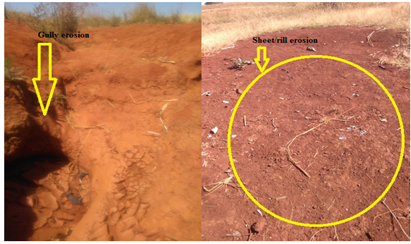
Figure 6: A plate showing a sign of soil erosion at western block (Amba 16 kebele)
Soil and water conservation is not being practiced in this block. Despite the presence of sheet erosion on 35 farms and steep slopes on several farms, none of the farms in the sample had established contour lines, terraces or other conservation measures to divert runoff and control soil erosion. Therefore, soil and water conservation in association with tree planting should be one of the first activities undertaken in this block.
2.Management Recommendations:
The Middle Western block is characterized by four main landforms: sloping hillsides, plains, depressions, and wetlands. Management recommendations will therefore cover all four areas with the intention that these areas serve as demonstration sites for best-bet / best management practices, which should then been up-scaled to the entire block. As such, three main areas have been selected.
The first area is located on the gentle plains and shallow depressions along the main road crossing the block (transect 5 & 6). The main activities in this area are livestock rearing and woodlots. The second area covers transect 11 and 12 as well as the area close to transect 15. This area is mainly made up of river buds, which are currently is under sorghum production; there are also some abandoned grasslands. The third area selected covers transect 9 and 13. This area consists of hill slopes and is located in the south-eastern corner of the block. The runoff from this area drains into the river bud and wetlands surrounding Nima stream.
The areas crossing the asphalt road to the west consist of intensive farms, and thus will not be the focus of the activities of the Mima model water shade project. Management recommendation for the Middle Western block (Amba 16) has been grouped into four main categories:
Promoting plantation of indigenous trees and grasses in and around the water shade
Conservation of wetlands and small streams
Improved pastures through use of paddocks
Increasing the woody vegetation cover with special focus on conservation of indigenous trees
Promotion of simple farming techniques to increase soil fertility and yields
Area 1: Management recommendations include improved pasture through use of paddocks. Majority of the farms in the area rear livestock, yet little attention is given to high quality feed. Farm sizes are relatively small and many farmers have a free grazing field (Anbessa forest). However, few farmers collect and feed high quality grass to improve the quality of the pastures. Improving animal nutrition is the key to increasing the quantity of milk produced. Therefore, in Area 1, the project should set up demonstration sites of improved paddocks. Grass species which will do well in this area and that can be used to improve pastures are listed in section 2.1.1.1. Additionally, the project should introduce Rhodes grass and other promising species for pasture improvement. The production of fodder legumes also needs to be explored.
Indigenous trees such as Albizia malacophylla and A. gummifera, Cordia abyssinica and Dycrostachus cinera, which are all hard wood species, can be found in the area and plantation should be expanded. Dycrostachus cinerais also palatable to livestock and could be used as a feed supplement. Croton macrostachyus and megalocarpus will also do well in this area, however both of these species are soft wood and not palatable to livestock. Acacia spp. should also be promoted since these are leguminous. Finally, the exotic Grevillea robusta could also be promoted for wood production.
Area 2: This area is situated on the plains, which often flood. Farmers are encroaching more and more into the river bud and wetlands and in many areas the channels draining the upland areas have been obstructed and destroyed. Therefore, many areas flood during the rainy season, affecting cereal production through flooding. There are very few trees in the landscape and sorghum and soya bean are cropped continuously with commercial fertilizers for the majority of the farms.
Management recommendations therefore include increasing the woody vegetation and setting up demonstration sites on better cereal production practices with the integration of crop rotation. Farmers need to be educated about the importance of wetlands and how best to manage these areas. The drainage channels need to be rehabilitated by the communities to ensure steady flow of water into the streams, which are part of the source area of Nima stream. Indigenous plant species should be promoted to increase the woody vegetation cover and for the production of fodder for livestock. Trees could also be introduced into some areas of the landscape to increase water use by the vegetation and promote ‘biodrainiage’.
Area 3: This area is located on the sloping hillsides from which water drains into the river bud situated below. The first activity to be undertaken in this area is the establishment of soil and water conservation and there is clearly need for training in the importance of such measures and interventions. Slopes in this area ranges between 1 and 10%. The integration of trees and legumes in soil and water conservation measures should be enhanced. The project should introduce ideas associated with contour planting for both conservation purposes and fodder production.
When promoting species, which are palatable to livestock, it is essential that the communities be sensitized to the need for controlling free-grazing. The project should build the capacity of the communities to develop by-laws governing free-grazing. More than 95% of the farmers experience problems with free-grazing animals from neighbouring farms and protected areas. Finally, activities which focus on soil fertility replenishment should be promoted. In this area, farms are very small and farmers need to intensify their production, which can be done through the integration of legumes and conservation agriculture.
Observation from field shows a greator infestation of farm fields by Striga, but this may be because the survey was conducted during the dry season. The field officer should look into this during activity planning and assess the importance of this problem. Low soil fertility levels and low use of fertilizer in the lock suggest that soil fertility and associated pest problems might be major constraints at farm level. Striga weeds grow well on poor soils with low soil fertility. Studies in Western Kenya, by Boye (2005) and Gacheru and Rao (2005), show that relay-cropping maize and beans with improved fallows reduce Striga infestation after a few rotations. At the same time, soil fertility is improved, and the farmer has additional benefits from the wood produced by the fallow crop, fodder and firewood.
Problems with apes and other wild animals are clearly significant in parts of the block and the project could look at alternatives for reducing these threats.
Now a days erratic rainfall is a major constraint at farm level in Ethiopia in general and in the region in particular. The erratic rainfall pattern of the area (Nima water shade) will likely to continue and perhaps worsening in the coming years because of climate change. Hence, interventions which increase soil cover, contribute to soil fertility, and diversify production should be given priority, since these interventions will buffer the harsh climatic conditions which are especially found in the prioritized water shade. Secondly, the few but heavy rains should be harvested in ponds and dams to ensure better water availability throughout the year. Hence, establishment of ponds and dams is another priority activity for the project.
This baseline report presents the results of the data collected from the combination of field and on farm surveys in three blocks of the Nima water shade. Interpretation and management recommendations are based solely on the data and do represent a consensus view between the Project and the survey results. It is imperative that before initiating any activities in the respective blocks, more information be collected for the targeted area chosen for interventions. It should be noted that recommendations made within this report are not based on any dialog with communities. It is therefore vital for the Project to establish a dialog with the target communities and farmers. These communities and farmers need to be actively involved in the process of prioritizing activities. Thus, the information contained within the report should provide support to the field officers of Nima model water shade, but the ultimate decisions concerning priorities need to be made based upon consensus between the communities and the Project.

Open Access By Aditum Open Access Journals id licensed under Creative Commons Attribution 4.0 International License. Based On a Work at aditum.org