International Journal of Advanced Interdisciplinary Research and Innovation
OPEN ACCESS | Volume 1 - Issue 1 - 2026
ISSN No: - | Journal DOI: 10.61148/IJAIRI


Lushwin P. B1*., Buyanova M. Oh2., Chelidze A.C3
1Independent expert, M., lushvin@mail.ru.
2Professor of Higher. School of Economics, M., mobuianova@mail.ru.
3pupil 11 class No. 627, M. 79255282876anna.chelidze@gmail.com.
*Corresponding author: Lushwin P. B, Independent expert, M., lushvin@mail.ru.
Received: September 02, 2026 | Accepted: September 12, 2026 | Published: September 17, 2026
Citation: Lushwin P.B., Buyanova M.Oh., Chelidze A.C. (2026) “Environmental Solution to the Problem of Navigation in Low Water on the Upper and Middle Volga” International Journal of Advanced Interdisciplinary Research and Innovation, 1(1); DOI: 10.61148/IJAIRI/001.
Copyright: © 2026 Lushwin P. B. This is an open access article distributed under the Creative Commons Attribution License, which permits unrestricted use, distribution, and reproduction in any medium, provided the original work is properly cited.
River Volga - the most important transport route of Russia. Between them are formed with depths of up to 0.5 m. The Volga-Kama cascade of reservoirs provided a navigable fairway with depths of 3.5-4 m. Problems for navigation remained in the areas near Nizhny Novgorod, where in the full-water years on navigational launches leaves ≈10 km3/g, in low-water - vessels idle (overload goods and transfer tourists to shallow-seated vessels - freight costs rise). To eliminate downtime, it is proposed to build for 40 billion. rub. low-pressure dam (extensive areas will flood), or the construction of several locks and dredging work on tens of kilometers. This article proposes an ecological, low-cost solution that dampens part of the negative from reservoirs - the formation of stagnant zones, where, according to biologists and remote sensing, reeds grow, evaporating at times more intensively than the water below them. By removing most of the weeds from the reeds on the Upper Volga will receive additional ≈5 km3/g water, Shipping required in low water.
Historical Sketch
In the transportation of goods from time immemorial, water routes have occupied a particularly important place. Along with the route “from the varangians to the Greeks” along the Dnieper through Kievan Russ, the Volga was the most important transport route in Eastern Europe, despite the fact that in the summer, hundreds of tumbles with depths of up to 0.5 m were formed on it. For communication of St. Petersburg with Russia Peter I the Vyshenevolotsk system was built, through which water is transferred to the Volga about 0.9 km3/g. With the advent of steamships in the middle of the XIX century, the situation became more complicated (steamboats can not be dragged). Since in the low-water years, due to insufficient summer runoff, large ships could not go higher than Rybinsk, the Upper Volga dam was built. Then, in the spring, the water came out of the spring, and the water came out of the spring the depth in the section at city Tver more than 25 cm, and together with the Zavodsky's reservoir, which is part of the Vyshnevolotsk system, >0.5 m. However, shallow areas above city Tver remained unsuitable for navigation. Even their names were “Cockroach Hole”, “Dog Sneak”.
Further efforts to improve navigation through the construction of longitudinal and transverse dams, narrowing the channel, did not produce the desired results on long sections. Only the creation of the Volga-Kama cascade of hydroelectric power plants (HPP) led to the formation of almost 4 thousand km of deep waterway with guaranteed depths (3.65 - 4 m), a decrease in the cost of transportation in the Volga basin by 2-3 times compared to railways, increase in freight from 27 million. ton in 1930 to 300 in 1990. Passenger traffic increased 3 times. Water, flood and energy problems were solved. However, such progress had the reverse side: flooding of territories; before the construction, the water from Rybinsk to Volgograd ran for 50 days (in a flood - for 30), now - for a year and a half. The self-purification of the Volga, the water of which 60-70 years ago was considered potable, has decreased tenfold, and the fishery value has also fallen (fig.1-3) [1,2,5,35,37-39].
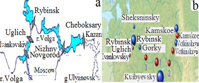
Figure 1. Modeling of the Volga-Kama cascade (a) [12]; electrostations and reservoir cascades (1 - Cheboksary, 2 - Nizhnekamsk, 3 - Nizhny Novgorod) (b) [38].
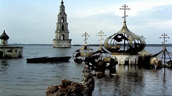
Figure 2. Rybinsk's reservoir [22].
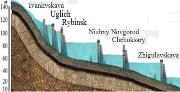
Figure 3. Cascade reservoirs upper and Middle Volga [7].
Problem area
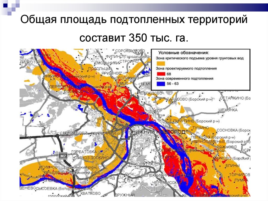
Problems in the interlude of low-water years remained areas near Nizhny Novgorod on the Gorodetsky site length of 54 km and Cheboksary (fig.4). On the rapids here in the middle of the court with a large draft pass during navigational launches from Rybinsk's and Gorky's reservoirs. In low-water years, water stored in the reservoirs there is not enough and have to overload cargoes, transfer tourists to shallow-sealing vessels, which significantly increases the cost of freight. There is a reservoir to eliminate this problem - Cheboksary (fig.5). But it’s not finished, he’s There is practically no useful capacity - the daily regulation of the flow uses a capacity between 62.5-63.3 m, which is not able to regulate the water level downstream. The reason for the project error — flooding ≈1000 km2 of land with an increase in the water level from the current 63 m to the projected 68 m [6,38,39], Strongly negative attitude of the population to the move.
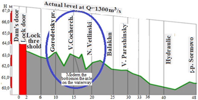
Figure 4. Longitudinal profile of the lower bieph of the Gorodetsky hydro-nodes in the ellipse is an empty plot [9].
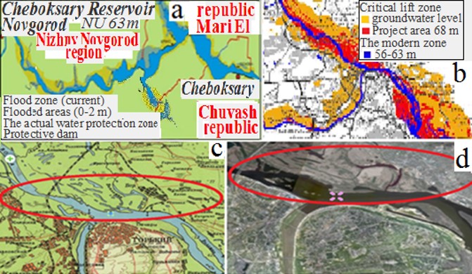
Figure 5. Cheboksary's reservoir: (a) [32], (b) [33]. Fragments of the map (c) and space image of Gorky's reservoir (d). In the ellipses of the flood zone [34].
As a result, the key for navigation on the Upper and Middle Volga is the water supply in the Rybinsk's reservoir. From 1947 to 2014 the inflow of water in the reservoir was 16-53 km3/g, this leads to changes in the water level in it during the year ≈4 m [1,6,10]. From 30 to 70% of the flow volume falls on the spring flood, part expended energy releases, Volume of navigation operation ≈10 km3. On Gorky's reservoir navigational discharge of only 0.6 km3 [21.38]. It consists of special discharges of water, navigation launches. They allow to maintain navigable depths below the sea level. Otherwise, shipping will stop. On the graph of expenditures in the summer months, this looks like a kind of comb (fig.6). Pdescents cause an increase in the water level behind the dam up to 2 m.
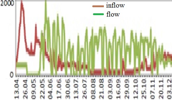
Figure 6. Inflow and flow of water through the Rybinsk's HPP in 2014 [20].
Due to the lack of water in Nizhniy Novgorod. Below the dam in the boundary, it is possible to maintain a depth of 3.5 m for 2-3 hours a day, which leads to underloading of river vessels, downtime in queues for locking, the industry incurs billions of dollars in losses. In 2014, due to the lack of flooding, underfilling of the reservoir (in fact, it was a natural disaster), water had to be saved, which created difficulties for navigation. Without a cascade. The Volga would become unnavigable, with water so polluted that its use would be ruled out. In 2015, due to low water in the internavigation period, launches through the Rybinsk's HPP were reduced by 2.5 times, from the standard 1200 m3/s to 450 m3/s, this limited the draught to 325 cm and in some places to 2.5 m. Preduced volume of cargo transportation by millions tonnes. In the shallows of spring 2024 there was a risk of stopping shipping on the Gorodetsky section, Ships up to 100. [6,19,24].
What to do? Save water and get used to living in low water conditions? According to the calculations of scientists, we are at the beginning of a low-water phase on the Volga, which can last another 20-30 years. To solve this problem, hydraulic engineers offer expensive measures: the construction of the Nizhny Novgorod low-pressure HPP for >40 billion. rub., reconstruction of existing and construction of additional locks, dams, many kilometers of dredging with subsequent cleaning them out of dust. The expected effect is growth, throughput in the township area up to 22 million tons cargoes [4,6,38].
Biophysical solution to the problem of ensuring uninterrupted navigation on the Middle Volga.
We offer a low-cost scheme-events: use a biological resource. Namely, a thicket of reeds, characteristic in the stagnant waters of shallow water and on the littoral. They evaporate water in the summer 3-5 times more intense than from the surface of the water Under the thickets (due to transpiration from sheets, the area of which is several times larger than the area of water under the thickets). With a decrease in insolation, the intensity of evaporation drops everywhere, and the contrasts in evaporation between different objects are leveled at times [31,36].
From 20 to 50% of the area of the Upper Volga reservoirs - shallow water (fig.7), table.1.
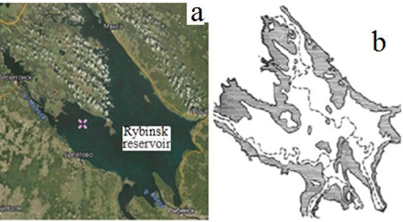
Figure 7. Space imagery the Rybinsk's reservoir (a) [22]. Scheme of shallow waters of the Rybinsk's reservoir. Temporary flooding zone shaded (b). Rivers are shown by
Table 1. Total shallow water reservoirs the Volga cascade
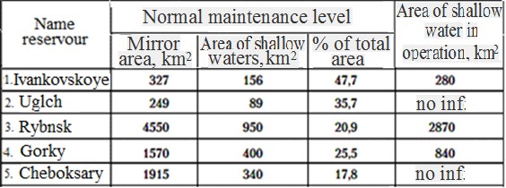
On them, a belt of aquatic and near-water vegetation has now formed along the coastal zone. According to hydrobiological estimates, from 4 to 40% of the areas of shallow waters of the Upper Volga reservoirs and the waters that flow into them in the (fig.8). In the Rybinsk's reservoir cane spreads intermittently, its area is ≈120 km2, the total area of thickets in the Upper Volga basin is ≈200 km2. Episodically limit the growth of thickets level mode and waves, height ≈2-2.5 m. The wind is blowing, and the wind is blowing, and the wind is blowing [17,18,28,29].
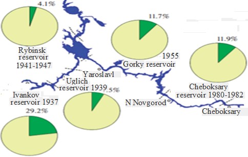
Figure 8. Reservoirs vegetation map Volga [16].
Before the sinking of the Rybinsk's reservoir in areas of future shallow water in swampy and flooded depressions, in coastal areas of rivers macrophytes occupied ≈40% of shallow water. After filling the reservoirs, the low-water areas of the Upper Volga began to grow. In 1989 - 2019, according to aerial and satellite images, as well as field studies, it began to reach 70-90%, spreading to depths of 1.8 m, occupying >70% of shallow water. If you remove most of this difficult to eradicate weed, which is done in Saratov and fragmentarily in the Tver's region (Fig.9), we get savings on evaporation of ≈3-5 km3/g (similar to the estimates in the Volga delta [11]), which is equivalent to a third-half the volume of navigational operation of the Rybinsk's reservoir, which is exactly what is missing in low-water years, will contribute to the production of environmental energy, will save conditional fuel.
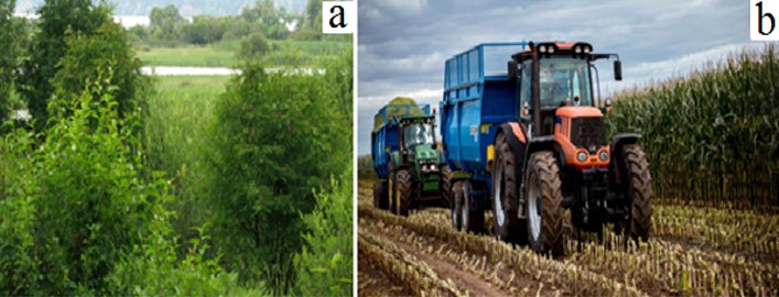
Figure 9. A view of the reeds, reeds of the lake bay of the Rybinsk's reservoir (a) [15]. Construction of the beach in city Tver (b) [26].
This will require two tractors, two motorboats, two vehicles, and two teams of cutthroats. To minimize the annual harvesting costs, reeds should be mowed in green form, on land, heavy equipment should be used on reeds, which cane tubers grind in the soil, making them unsuitable for reproduction Note that when commissioning the cascade reservoirs, the connection of the areas of reed thickets with river runoff and navigation was not considered due to the lack of large-scale thickets on the flowing river. However, 10-15 years after filling the reservoirs the formation of stagnant water areas and the appearance in them of the rudiments of aquatic plants along the coastal zone, lakes and rivers formed a belt of water and near-water vegetation, with a predominance of reeds - macrophytes [3,8,11].
What is “harmful” and “useful” cane?
Cane growth increases the risk of fires. They are the best breeding grounds for mosquitoes and other blood-sucking insects - gadflies and horseflies, as well as. They are the ones who have the power to heal the sick [14,23,25,27]. On the other side of the fence, it prevents water from blooming breeding and feeding grounds of birds and fish. Canes are used in oriental medicine, as litter and silage for animals, as insulation and roofing material, in the pulp and paper industry, etc.
Since and in the long term, it is not expected to solve the problem of forecasting river flow and water use indicators with the necessary accuracy, and therefore engineering management of river flow, in order to reduce the negative consequences of low water, it is advisable to minimize evaporation losses in watercourses flowing into the Volga and in the future. Optimize the area of reeds. Especially because their distribution was associated with anthropogenic activities [1,13,30].
The relevance of the above is confirmed by the current situation and plans of industries, for example, the growth of the volume of transported goods, the need for reconstruction of hydraulic structures, the development of the river fleet. According to Rosmorrechflot in Russia in 2023 operated ≈14 thousand ships, including 1,300. passengers. Total need for construction of vessels ≈0.7 thousand. Some of them are already in production [35].
Conclusions.
The proposed biophysical solution to the problem of navigation in shallow water on the Upper and Middle Volga is economical and environmentally friendly. Elimination in the Upper Volga basin of most of tore-eradicated weeds- macrophytes will give savings on evaporation up to ≈3-5 km3/g, what exactly is missing in low-water years, will prevent flooding of territories, will reduce the cost of freight by tens of billions. rub., will contribute to the development of environmental energy, contingent fuel savings.
Cane beds are part of the ecosystem. It was human intervention that led to their growth, up to regional domination and environmental disasters. Should be do not completely destroy the reed beds. In order to preserve the ecosystem (nesting places of waterfowl and fish spawning), it is necessary to properly manage rapidly renewable biomass of reeds, leave macrophytes on a quarter - half of the length of the coastal littoral with the arrangement of gaps in the thickets.

Open Access By Aditum Open Access Journals id licensed under Creative Commons Attribution 4.0 International License. Based On a Work at aditum.org